Home › Escalante, Utah › Calf Creek Falls
No dirt road required
Lower Calf Creek Falls
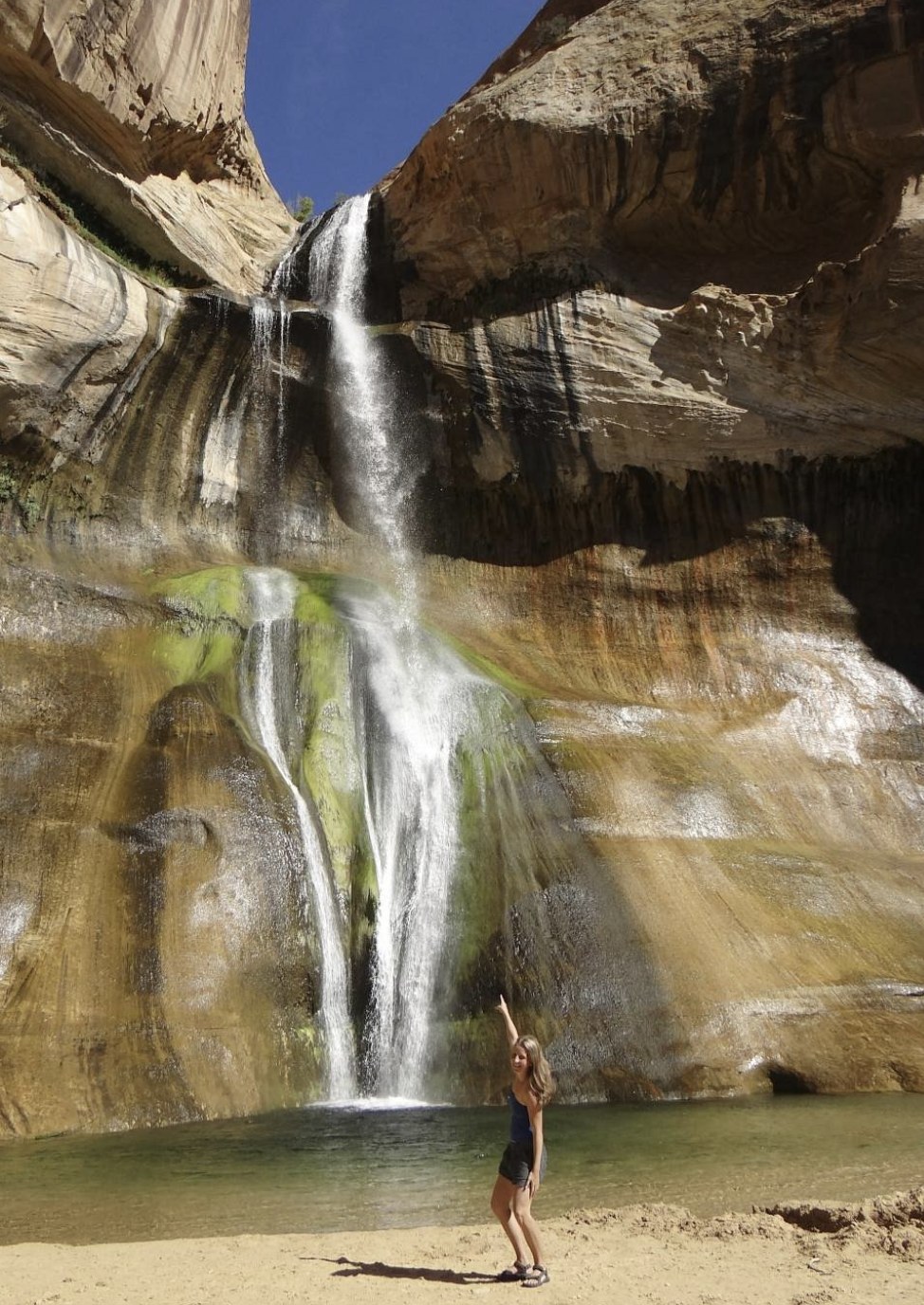
A 126 foot waterfall fed by springs all year, six miles round trip, reached entirely on pavement. It is the one marquee hike here you can do in any car, on any day, without a plan.
Start here
The easiest great hike in the area, and the busiest
Almost everything else worth walking to around Escalante involves an hour of dirt road and a decision about your tyres. Calf Creek does not. The trailhead sits 15 miles east of town directly on Scenic Byway 12, the trail is a six mile out and back that BLM rates moderate, and the payoff is a 126 foot waterfall that runs all year because it is spring fed rather than storm fed.
If you have one afternoon and a hire car you are not willing to abuse, this is the hike.
It is also the one place here that reliably has other people on it, for exactly those reasons. That is not a reason to skip it. Start early, or go late in the day when the light on the alcove walls is better anyway.
One more thing worth knowing given everything else on this site: Calf Creek Canyon is named in the 2026 proclamation as part of the Canyons of the Escalante Unit, which makes it one of the few marquee destinations here that is still inside the national monument. See the boundary change.
What the walk is like
The hike
Six miles round trip from the campground trailhead, following the creek up a canyon of red alcoved walls and white slickrock. The gradient is gentle throughout, which is why it gets called easy, but there are two things that make it harder work than the profile suggests.
- Deep sand. Long stretches of the trail are loose sand, which is tiring in a way that mileage does not capture. Budget more time than six flat miles would normally need.
- Exposure. Much of the walk is open to the sun. In summer this is the whole story, and it is the reason to start early rather than at midday.
Along the way there are interpretive stops, and there is rock art visible on the canyon walls if you know where to look. Ask at the trailhead or the visitor center rather than scrambling to find it, and do not approach or touch any panel. Defacing rock writing sites is prohibited and carries civil and criminal penalties.
At the end, the falls drop into a pool that stays cold year round. People swim, and in July that is most of the point.
Practicalities
Fees, parking and the campground
BLM charges a day use fee of $5 per vehicle at the Calf Creek Recreation Area. Interagency pass holders get day use free. There is no overnight camping at the day use site.
The campground at the trailhead has 13 sites at $15 a night, first come first served, open year round, with toilets, picnic tables and fire rings. It does not accommodate oversized vehicles. Senior and Access pass holders get 50 percent off camping fees. With 13 sites at a trailhead this popular it fills early in season, so treat it as a piece of luck rather than a plan. More on camping options.
The parking is the constraint
The lot is small relative to the popularity of the hike and it is shared with the campground. Mid morning on a spring weekend is the worst time to arrive. Early, or after about 3pm, and you will usually be fine.
Day use reservations are accepted on non holiday days at $75 per day, which is a group booking arrangement rather than something an individual hiker needs.
The other one
Upper Calf Creek Falls
There is a second waterfall on the same creek, reached from a separate trailhead further up Byway 12 toward Boulder. It is a different proposition entirely: much shorter, much steeper, and far quieter.
Six miles round trip, gentle gradient, sandy, busy, a 126 foot waterfall, paved access and a $5 fee. The one most people mean when they say Calf Creek.
Shorter and steeper, descending slickrock from the rim. Far fewer people. The trailhead access is rougher than the Lower falls and worth asking about before you commit a low clearance car.
We have not verified the Upper trail's exact distance or the trailhead road condition from a land manager source, so we are not going to publish a figure we cannot stand behind. Ask at the visitor center, which is the right call anyway because the access road condition changes.
Timing
When to go
Spring and autumn
Best walking weather. April and May average under an inch of rain between them, October is cooler and quieter. Start early either way, because this is the busiest trail in the area.
Summer
Hot and exposed, with July averaging a 92°F high. Start at first light or go late afternoon. The pool at the end is the compensation and it is a real one.
Winter
Quiet and often lovely, with the falls sometimes partly frozen. Cold, short days, and the trail can be icy in shaded sections. Fewer people than any other time.
Because the falls are spring fed they run year round rather than depending on recent rain, which is unusual here and is why this hike is reliable when the rest of the area is weather dependent. Month by month detail on best time to visit.
Kit
What to bring
- More water than the distance suggests. Sand and sun make six miles feel longer than six miles.
- Sun protection, because much of the trail is open.
- Shoes you do not mind filling with sand.
- Swimming things in summer, and the knowledge that the pool is cold whatever the air temperature.
- Cash or a card for the $5 fee, or your interagency pass.
- Everything packed out, including food waste. Orange peel takes up to a decade to break down here.
No permit is needed for this hike, as with almost everything else in the area. See permits for the full picture, and note that this is one of the few places with any fee at all.
Unlike the slot canyons, Calf Creek is an open canyon with a perennial creek rather than a drain, so the flash flood calculus is different here. It is not zero risk in a storm, but it is not the same hazard as standing in a ten inch wide slot.
Questions we actually get
Frequently asked
How long is the Lower Calf Creek Falls hike?
Six miles round trip, described by BLM as a moderate hike, starting from the Calf Creek campground 15 miles east of Escalante on Highway 12. The gradient is gentle but long stretches of deep sand make it more tiring than the distance suggests.
Is there a fee for Calf Creek Falls?
Yes, $5 per vehicle for day use of the Calf Creek Recreation Area. Interagency pass holders get day use free. There is no permit required, just the vehicle fee, which makes this one of the few places in the area that charges anything at all.
Can I get to Calf Creek Falls without a four wheel drive?
Yes. The trailhead is directly on Scenic Byway 12, which is paved the whole way from Escalante. This is the main reason it is the most popular hike in the area and the easiest to fit into a day when the dirt roads are wet.
Can you swim at Lower Calf Creek Falls?
People do. The falls drop into a pool that stays cold year round because the creek is spring fed rather than storm fed. In summer that is a large part of the appeal.
Can I camp at the Calf Creek trailhead?
There is a 13 site campground at the trailhead, $15 a night, first come first served, open year round, with toilets, picnic tables and fire rings. It does not take oversized vehicles and it fills early in season. There is no overnight camping at the day use site itself.
Is Calf Creek Falls still in the national monument?
Yes. Calf Creek Canyon is named in the 2026 proclamation as part of the Canyons of the Escalante Unit, making it one of the few marquee destinations here still inside the monument after the boundary was reduced in September 2026.
Do this one, then go deeper
Calf Creek is the easy introduction. The canyons down the dirt road are the reason to stay a second night.
Making a day of the drive? See Scenic Byway 12 and every tour category.
Paved access, $5 a vehicle, no permit. The reliable option on a wet day.
Plan the rest